| Rep. Peter DeFazio Launches Attack
on Galice Creek and Grave Creek
On November 18th, 2011, Representative
Peter DeFazio introduced legislation to expand the wild section of the
Rogue River. This comes off the back of Oregon Governor John Kitzhaber
writing
a letter to Ken Salazar naming the Rogue River as a "crown jewel" on
October 6th, 2011. Kitzhaber's letter was a response to a general request
from Salazar requesting that local and state governments make suggestions
on more areas of Public Land to lock up under quasi wilderness designation.
DeFazio's current legislation
is his third attempt to steal important mineral, timber and water resources
on the Rogue River from citizens. The current legislation seeks to not
only lock up an additional 58,000 acres of land, but also seeks to permanently
withdraw 93 stream miles of waterways under a wild and scenic designation
which would also take in a corridor of 1/4 of a mile on each side of the
waterway. Streams included within their attack include such notably rich
Rogue River tributaries as Galice Creek, Grave Creek, Quartz Creek, Whiskey
Creek, Kelsey Creek, Howard Creek, Bailey Creek and dozens of others.
Included within the legislation
is the naming of the "roadless area" in honor of legendary Western author,
Zane Grey who was a regular visitor to this section of the Rogue River
during the 1920's. The "stick in the eye" so to speak, is that Zane Grey
was widely known as a friend to Galice miners and particularly to the legendary
Harry Lewis who operated not only the Rocky Gulch Placer, but also later
leased the famous Old Channel Mine. Grey typically used the Lewis Ranch
at Rocky Bar as a staging area for his fishing trips and many stories are
still told by Galice old timers about Grey's visits to the Lewis place.
Remnants of the Harry Lewis Ranch can still be seen above Rocky Bar today,
along with evidence of his mine workings which was mainly worked by hydraulic
and later steam shovel means. Zane Grey did much to popularize fishing
and recreation on the Rogue River near Galice, with his articles in sportsman
magazines, but also especially his books "Tales of Fresh Water Fishing"
(1928) and "Rogue River Feud" (1929). Up until this time, this section
of the Rogue River was largely populated only by miners, who felt a particularly
close affinity to the area and to the river. Throngs of fishermen soon
crowded the banks of the river near Galice and Grey, with much regret,
soon left the Rogue River, feeling that it had been overfished and ruined.
For the remainder of his life, he focused his fishing efforts on the North
Umpqua and did so very quietly for fear of it becoming over-fished.
As wild as Galice may still
be, contrary to the utter nonsense spouted by DeFazio, Kitzhaber and their
cohorts in organizations like KS Wild, the area around Galice is far from
being a pristine wilderness. This area is foremost a district of rich mines
and the evidence of mining in the area is so very apparent that it stands
as a great symbol of Southern Oregon's mining history. In the meantime,
it is still very much a mining area to the extent that it is a little known
fact that most of its full time residents are in fact, independent miners.
In this sense, Galice Creek and Grave Creek stand almost as holy places
among the mining community and it is important that this legislation is
beaten back.
Miners everywhere are requested
to do their part, by writing to the Josephine County Board of Commissioners
and to ask them to oppose the takings of Galice Creek and Grave Creek.
Commissioner Cassanelli:
scassanelli@co.josephine.or.us
Commissioner Hare: share@co.josephine.or.us
Commissioner Reedy: dreedy@co.josephine.or.us
You can also send a strong
message to Peter DeFazio to keep his hands off the Rogue River and its
tributaries, by utilizing the following contact page:
https://forms.house.gov/defazio/IMA/contact.html
You can also call his office
at Washington DC at: (202) 225-6416
The following letter was
sent to the duly elected officials of Josephine County, Oregon from the
Jefferson Mining District on December 2nd, 2011.
Please find attached, a map
of the proposed Zane Grey Roadless Area (aka. Wild Rogue). This
map was produced by Erik Fernandez of Oregon Wild out of Portland.
While we miners find the
proposed wilderness designation alarming enough, I would like to draw your
attention to a little known element of this bill, which seeks to also withdraw
large portions of Grave Creek and Galice Creek, as well as many other lesser
known waterways from mineral entry and future water projects. On the attached
map, these areas are highlighted in pink.
If accomplished, this bill
will successfully lock up some of the most mineral rich ground in Josephine
County and put out of production, until BLM has the funds and resources
to conduct validity tests, scores of privately held mineral claims in this
county. Due to the current state of the local economy, Josephine County's
residents cannot afford to have some of our most precious mineral lands
locked up. In the past, this type of legislation has been known to halt
mining on existing mineral claims for a period of five to twenty years,
if not permanently.
Gold was first discovered
on Galice Creek in February of 1852 by a small group of prospectors that
included James Tuffs, Ebenezer Dimmick, Jimmie TwoGood, Hardy Eliff and
Joseph Knotts. For the next five years, hostilities between Euro-American
settlers and Native Americans prevented the mineral resources of Galice
Creek and tributaries from being extracted and it wasn't until early 1857
that mining in Galice got off the ground. By the spring of that year, the
community of Galleisburg (also sometimes referred to as "Upper Town") was
established at the mouth of Galice Creek. Another community, known as "Lower
Town" was also established nearby. The nearby placer ground was said to
be so rich that a hard working man with a pick, shovel and gold pan could
glean two ounces of gold each day. The following year, 1858, lode mining
got its start in Galice with the famous Sugar Pine discovery on Quartz
Creek, which is the oldest lode gold mine in Josephine County. Over the
next 80 years, over 5 million ounces of gold were gleaned from Galice Creek
and the surrounding hills, both placer and lode, as well as large quantities
of copper, platinum, chrome, manganese, iron, silica and rare earth minerals.
Despite the fact that it is little spoken about today, due in large part
because excessive regulations, run amok federal agencies and ever meddling
environmentalists encourage local miners to be very tight lipped about
their activities, let alone their results, every year, large quantities
of gold are still recovered in the vicinity of Galice. Most of this gold,
which is distinct due to its high purity, is recovered by the hard work
of residents of Josephine County who utilize it to pay their bills and
to put food on their family tables. Meanwhile, nearby Grave Creek, an area
which is very similar in mineralization to Galice Creek, is an equally
rich mining area. Like Galice, its gold is distinct and noted for its exceptionally
high purity. Mining on Grave Creek began around the same time that it did
on Galice Creek, with its total production being equal to, if not somewhat
greater than that at Galice.
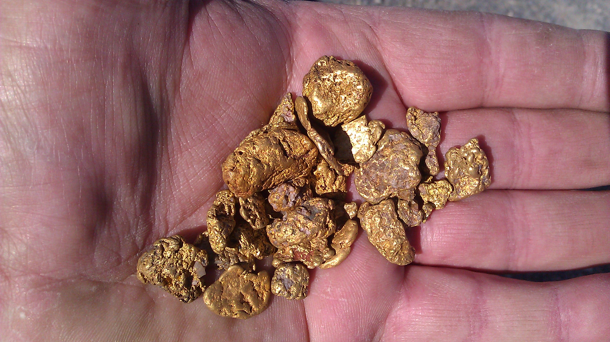
Best historical estimates
confirm that the total aggregate gold production of Galice and Grave Creeks
is in excess of some ten million ounces, amounting to nearly 20% of Southern
Oregon's total historical gold production. Despite this, most geologists
and miners are in agreement that less than 10% of the gold in these two
areas has actually been recovered to date. In fact, there is still sufficient
enough gold reserves in that area that gold can easily be found by even
small children with their hands, a simple gold pan and a little instruction,
almost anywhere in the area described. These two areas are also very rich
in native copper, silver, platinum, silica, iron, nickel, chromite and
also numerous rare earth minerals, all of which are required for not only
the most basic of manufacturing, but especially for high technology products.
Worldwide, there is tremendous
interest in the gold and other mineral reserves of Galice and Grave Creeks.
Despite this, most of the privately held mineral claims are actually in
the hands of local citizens who are anxious for the opportunity to extract
the minerals from their properties. Unlike other business sectors in this
area, which all too often seem to have their hand out for economic development
support from the county, the miners and mineral claim owners ask for nothing
except for the opportunity to simply be left alone to do their work without
constant harassment and interference by non governmental organizations,
lack-of-authority agencies and their elected cohorts who reside in far
away places that are not immediately impacted by their obstructive activities.
This current situation is completely out of line with the intent of the
Mining Law of the United States, which through the Acts of Congress in
1866, 1870 and 1872, granted the valuable minerals of this nation to the
people of this country for their benefit on the sole condition that they
should go out and possess them. This type of obstruction, harassment and
meddling adversely impacts the health of our local economy, our ability
to self-sustain and our security, and results in the unconstitutional takings
of the mineral properties owned by many citizens of Josephine County. To
my knowledge, not a single claim owner was contacted by the appropriate
federal agency to allow them the opportunity to co-ordinate or to even
inform them that their exclusively possessed mineral property might be
adversely impacted by this legislation. This is completely contrary to
the requirements of federal law and illustrates the total disregard that
is shown to the citizens of this county by the federal government.
As the duly elected chairman
of the Jefferson Mining District, a lawful and existing miner's government
established in accordance to the provisions of the Mining Law of the United
States, I would like to request your support to help protect the
mineral resources of Galice Creek, Grave Creek and the surrounding areas
from further restrictions and impediments, by actively opposing the Zane
Grey Wilderness and especially the withdrawal of Galice and Grave Creeks.
Regards,
Kerby Jackson
Chairman - Jefferson Mining
District
HR 3436 112th CONGRESS
1st Session
H. R. 3436
To expand the Wild Rogue
Wilderness Area in the State of Oregon, to make additional wild and scenic
river designations in the Rogue River area, and to provide additional protections
for Rogue River tributaries, and for other purposes.
IN THE HOUSE OF REPRESENTATIVES
November 16, 2011
Mr. DEFAZIO (for himself,
Mr. SCHRADER, and Mr. BLUMENAUER) introduced the following bill; which
was referred to the Committee on Natural Resources
--------------------------------------------------------------------------------
A BILL
To expand the Wild Rogue
Wilderness Area in the State of Oregon, to make additional wild and scenic
river designations in the Rogue River area, and to provide additional protections
for Rogue River tributaries, and for other purposes.
Be it enacted by the Senate
and House of Representatives of the United States of America in Congress
assembled,
SECTION 1. EXPANSION OF WILD
ROGUE WILDERNESS AREA.
(a) Expansion- In accordance
with the Wilderness Act (16 U.S.C. 1131 et seq.), certain Federal land
managed by the Bureau of Land Management, comprising approximately 58,100
acres, as generally depicted on the map entitled `Wild Rogue', dated September
16, 2010, are hereby included in the Wild Rogue Wilderness, a component
of the National Wilderness Preservation System.
(b) Maps and Legal Descriptions-
(1) IN GENERAL- As soon
as practicable after the date of enactment of this Act, the Secretary of
the Interior shall file a map and a legal description of the wilderness
area designated by this section, with--
(A) the Committee on Energy
and Natural Resources of the Senate; and
(B) the Committee on Natural
Resources of the House of Representatives.
(2) FORCE OF LAW- The maps
and legal descriptions filed under paragraph (1) shall have the same force
and effect as if included in this subtitle, except that the Secretary may
correct typographical errors in the maps and legal descriptions.
(3) PUBLIC AVAILABILITY-
Each map and legal description filed under paragraph (1) shall be on file
and available for public inspection in the appropriate offices of the Bureau
of Land Management.
(c) Administration- Subject
to valid existing rights, the area designated as wilderness by this section
shall be administered by the Secretary of the Interior in accordance with
the Wilderness Act (16 U.S.C. 1131 et seq.).
(d) Withdrawal- Subject
to valid rights in existence on the date of enactment of this Act, the
Federal land designated as wilderness by this section is withdrawn from
all forms of--
(1) entry, appropriation,
or disposal under the public land laws;
(2) location, entry, and
patent under the mining laws; and
(3) disposition under all
laws pertaining to mineral and geothermal leasing or mineral materials.
SEC. 2. WILD AND SCENIC
RIVER DESIGNATIONS, ROGUE RIVER AREA.
(a) Amendments- Section
3(a)(5) of the Wild and Scenic Rivers Act (16 U.S.C. 1274(a)(5)) (relating
to the Rogue River, Oregon) is amended by adding at the end the following:
`In addition to the segment
described in the previous sentence, the following segments in the Rogue
River area are designated:
`(A) KELSEY CREEK- The approximately
4.8 miles of Kelsey Creek from east section line of T32S, R9W, sec. 34,
W.M. to the confluence with the Rogue River as a wild river.
`(B) EAST FORK KELSEY CREEK-
The approximately 4.6 miles of East Fork Kelsey Creek from the Wild Rogue
Wilderness boundary in T33S, R8W, sec. 5, W.M. to the confluence with Kelsey
Creek as a wild river.
`(C) WHISKY CREEK-
`(i) The approximately 0.6
miles of Whisky Creek from the confluence of the East Fork and West Fork
to 0.1 miles downstream from road 33-8-23 as a recreational river.
`(ii) The approximately
1.9 miles of Whisky Creek from 0.1 miles downstream from road 33-8-23 to
the confluence with the Rogue River as a wild river.
`(D) EAST FORK WHISKY CREEK-
`(i) The approximately 2.8
miles of East Fork Whisky Creek from the Wild Rogue Wilderness boundary
in T33S, R8W, sec. 11, W.M. to 0.1 miles downstream of road 33-8-26 crossing
as a wild river.
`(ii) The approximately
.3 miles of East Fork Whisky Creek from 0.1 miles downstream of road 33-8-26
to the confluence with Whisky Creek as a recreational river.
`(E) WEST FORK WHISKY CREEK-
The approximately 4.8 miles of West Fork Whisky Creek from its headwaters
to the confluence with Whisky Creek as a wild river.
`(F) BIG WINDY CREEK-
`(i) The approximately 1.5
miles of Big Windy Creek from its headwaters to 0.1 miles downstream from
road 34-9-17.1 as a scenic river.
`(ii) The approximately
5.8 miles of Big Windy Creek from 0.1 miles downstream from road 34-9-17.1
to the confluence with the Rogue River as a wild river.
`(G) EAST FORK BIG WINDY
CREEK-
`(i) The approximately 0.2
miles of East Fork Big Windy Creek from its headwaters to 0.1 miles downstream
from road 34-8-36 as a scenic river.
`(ii) The approximately
3.7 miles of East Fork Big Windy Creek from 0.1 miles downstream from road
34-8-36 to the confluence with Big Windy Creek as a wild river.
`(H) LITTLE WINDY CREEK-
The approximately 1.9 miles of Little Windy Creek from 0.1 miles downstream
of road 34-8-36 to the confluence with the Rogue River as a wild river.
`(I) HOWARD CREEK-
`(i) The approximately 0.3
miles of Howard Creek from its headwaters to 0.1 miles downstream of road
34-9-34 as a scenic river.
`(ii) The approximately
6.9 miles of Howard Creek from 0.1 miles downstream of road 34-9-34 to
the confluence with the Rogue River as a wild river.
`(J) MULE CREEK- The approximately
6.3 miles of Mule Creek from east section line of T32S, R10W, sec. 25,
W.M to the confluence with the Rogue River as a wild river.
`(K) ANNA CREEK- The approximately
3.5-mile section of Anna Creek from its headwaters to the confluence with
Howard Creek as a wild river.
`(L) MISSOURI CREEK- The
approximately 1.6 miles of Missouri Creek from the Wild Rogue Wilderness
boundary in T33S, R10W, sec. 24, W.M. to the confluence with the Rogue
River as a wild river.
`(M) JENNY CREEK- The approximately
1.8 miles of Jenny Creek from the Wild Rogue Wilderness boundary in T33S,
R9W, sec.28, W.M. to the confluence with the Rogue River as a wild river.
`(N) RUM CREEK- The approximately
2.2 miles of Rum Creek from the Wild Rogue Wilderness boundary in T34S,
R8W, sec. 9, W.M. to the confluence with the Rogue River as a wild river.
`(O) EAST FORK RUM CREEK-
The approximately 1.5 miles of East Rum Creek from the Wild Rogue Wilderness
boundary in T34S, R8W, sec. 10, W.M. to the confluence with Rum Creek as
a wild river.
`(P) WILDCAT CREEK- The
approximately 1.7-mile section of Wildcat Creek from its headwaters downstream
to the confluence with the Rogue River as a wild river.
`(Q) MONTGOMERY CREEK- The
approximately 1.8-mile section of Montgomery Creek from its headwaters
downstream to the confluence with the Rogue River as a wild river.
`(R) HEWITT CREEK- The approximately
1.2 miles of Hewitt Creek from the Wild Rogue Wilderness boundary in T33S,
R9W, sec. 19, W.M. to the confluence with the Rogue River as a wild river.
`(S) BUNKER CREEK- The approximately
6.6 miles of Bunker Creek from its headwaters to the confluence with the
Rogue River as a wild river.
`(T) DULOG CREEK-
`(i) The approximately 0.8
miles of Dulog Creek from its headwaters to 0.1 miles downstream of road
34-8-36 as a scenic river.
`(ii) The approximately
1.0 miles of Dulog Creek from 0.1 miles downstream of road 34-8-36 to the
confluence with the Rogue River as a wild river.
`(U) QUAIL CREEK- The approximately
1.7 miles of Quail Creek from the Wild Rogue Wilderness boundary in T33S,
R10W, sec. 1, W.M. to the confluence with the Rogue River as a wild river.
`(V) MEADOW CREEK- The approximately
4.1 miles of Meadow Creek from its headwaters to the confluence with the
Rogue River as a wild river.
`(W) RUSSIAN CREEK- The
approximately 2.5 miles of Russian Creek from the Wild Rogue Wilderness
boundary in T33S, R8W, sec. 20, W.M. to the confluence with the Rogue River
as a wild river.
`(X) ALDER CREEK- The approximately
1.2 miles of Alder Creek from its headwaters to the confluence with the
Rogue River as a wild river.
`(Y) BOOZE CREEK- The approximately
1.5 miles of Booze Creek from its headwaters to the confluence with the
Rogue River as a wild river.
`(Z) BRONCO CREEK- The approximately
1.8 miles of Bronco Creek from its headwaters to the confluence with the
Rogue River as a wild river.
`(AA) COPSEY CREEK- The
approximately 1.5 miles of Copsey Creek from its headwaters to the confluence
with the Rogue River as a wild river.
`(BB) CORRAL CREEK- The
approximately 0.5 miles of Corral Creek from its headwaters to the confluence
with the Rogue River as a wild river.
`(CC) COWLEY CREEK- The
approximately 0.9 miles of Cowley Creek from its headwaters to the confluence
with the Rogue River as a wild river.
`(DD) DITCH CREEK- The approximately
1.8 miles of Ditch Creek from the Wild Rogue Wilderness boundary in T33S,
R9W, sec. 5, W.M. to its confluence with the Rogue River as a wild river.
`(EE) FRANCIS CREEK- The
approximately 0.9 miles of Francis Creek from its headwaters to the confluence
with the Rogue River as a wild river.
`(FF) LONG GULCH- The approximately
1.1 miles of Long Gulch from the Wild Rogue Wilderness boundary in T33S,
R10W, sec. 23, W.M. to the confluence with the Rogue River as a wild river.
`(GG) BAILEY CREEK- The
approximately 1.7 miles of Bailey Creek from the west section line of T34S,
R8W, sec.14, W.M. to the confluence of the Rogue River as a wild river.
`(HH) SHADY CREEK- The approximately
0.7 miles of Shady Creek from its headwaters to the confluence with the
Rogue River as a wild river.
`(II) SLIDE CREEK-
`(i) The approximately 0.5-mile
section of Slide Creek from its headwaters to 0.1 miles downstream from
road 33-9-6 as a scenic river.
`(ii) The approximately
0.7-mile section of Slide Creek from 0.1 miles downstream of road 33-9-6
to the confluence with the Rogue River as a wild river.'.
(b) Management- All wild,
scenic, and recreation classified segments designated by the amendment
made by subsection (a) shall be managed as part of the Rogue Wild and Scenic
River.
(c) Withdrawal- Subject
to valid rights, the Federal land within the boundaries of the river segments
designated by the amendment made by subsection (a) is withdrawn from all
forms of--
(1) entry, appropriation,
or disposal under the public land laws;
(2) location, entry, and
patent under the mining laws; and
(3) disposition under all
laws pertaining to mineral and geothermal leasing or mineral materials.
SEC. 3. ADDITIONAL PROTECTIONS
FOR ROGUE RIVER TRIBUTARIES.
(a) Protections- The Federal
Energy Regulatory Commission shall not license the construction of any
dam, water conduit, reservoir, powerhouse, transmission line, or other
project works on or directly affecting any stream which is listed in this
section, and no department or agency of the United States shall assist
by loan, grant, license, or otherwise in the construction of any water
resources project on or directly affecting any stream which is listed in
this section of this Act, except to maintain or repair water resources
projects that exist on the date of enactment of this Act. Nothing in this
section shall prohibit any department or agency of the United States in
assisting by loan, grant, license, or otherwise, water resources projects
whose primary purpose is ecological or aquatic restoration and which provide
a net benefit to water quality and aquatic resources.
(b) Withdrawal- Subject
to valid rights, the Federal land within a quarter-mile on each side of
the streams listed in this section, is withdrawn from all forms of--
(1) entry, appropriation,
or disposal under the public land laws;
(2) location, entry, and
patent under the mining laws; and
(3) disposition under all
laws pertaining to mineral and geothermal leasing or mineral materials.
(c) Stream Segments-
(1) KELSEY CREEK- The approximately
4.5 miles of Kelsey Creek from its headwaters to the east section line
of 32S 9W sec. 34.
(2) EAST FORK KELSEY CREEK-
The approximately .2 miles of East Fork Kelsey Creek from its headwaters
to the Wild Rogue Wilderness boundary in 33S 8W sec. 5.
(3) EAST FORK WHISKY CREEK-
The approximately .7 miles of East Fork Whisky Creek from its headwaters
to the Wild Rogue Wilderness boundary in 33S 8W section 11.
(4) LITTLE WINDY CREEK-
The approximately 1.2 miles of Little Windy Creek from its headwaters to
west section line of 33S 9W sec. 34.
(5) MULE CREEK- The approximately
5.1 miles of Mule Creek from its headwaters to east section line of 32S
10W sec. 25.
(6) MISSOURI CREEK- The
approximately 3.1 miles of Missouri Creek from its headwaters to the Wild
Rogue Wilderness boundary in 33S 10W sec. 24.
(7) JENNY CREEK- The approximately
3.1 miles of Jenny Creek from its headwaters to the Wild Rogue Wilderness
boundary in 33S 9W sec. 28.
(8) RUM CREEK- The approximately
2.2 miles of Rum Creek from its headwaters to the Wild Rogue Wilderness
boundary in 34S 8W sec. 9.
(9) EAST FORK RUM CREEK-
The approximately .5 miles of East Fork Rum Creek from its headwaters to
the Wild Rogue Wilderness boundary in 34S 8W sec. 10.
(10) HEWITT CREEK- The approximately
1.4 miles of Hewitt Creek from its headwaters to the Wild Rogue Wilderness
boundary in 33S 9W sec. 19.
(11) QUAIL CREEK- The approximately
.8 miles of Quail Creek from its headwaters to the Wild Rogue Wilderness
boundary in 33S 10W sec. 1.
(12) RUSSIAN CREEK- The
approximately .1 miles of Russian Creek from its headwaters to the Wild
Rogue Wilderness boundary in 33S 8W sec. 20.
(13) DITCH CREEK- The approximately
.7 miles of Ditch Creek from its headwaters to the Wild Rogue Wilderness
boundary in 33S 9W sec. 5.
(14) LONG GULCH- The approximately
1.4 miles of Long Gulch from its headwaters to the Wild Rogue Wilderness
boundary in 33S 10W sec. 23.
(15) BAILEY CREEK- The approximately
1.4 miles of Bailey Creek from its headwaters to west section line of 34S
8W sec. 14.
(16) QUARTZ CREEK- The approximately
3.3 miles of Quartz Creek from its headwaters to its confluence with the
North Fork Galice Creek.
(17) NORTH FORK GALICE CREEK-
The approximately 5.7 miles of the North Fork Galice Creek from its headwaters
to its confluence with Galice Creek.
(18) GRAVE CREEK- The approximately
10.2 mile section of Grave Creek from the confluence of Wolf Creek downstream
to the confluence with the Rogue River.
(19) CENTENNIAL GULCH- The
approximately 2.2 miles of Centennial Gulch from its headwaters to its
confluence with the Rogue River.
|