|
Jefferson Mining District
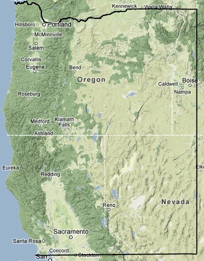
Born out of a project of SWOMA, Jefferson Mining District is a lawful miner's government established according to the provisions outlined in the Acts of 1866 and 1872 (codified RS 2319 and 30 USC 22) and serving the miners within the mining districts of South Western Oregon and Northern California. Our district territory commences at about 37° 59' 45 N. Lat., 123° 01' 16 W. Lon., known as Point Reyes; thence, Due East to a point at about 37° 59' 45 N. Lat., 118° 33' 45 W. Lon., North of Pizona; thence, Northward to a point at about 43° 55' 47 N. Lat., 118° 33' 45 W. Lon., North of Coyote Cr., and Malheur River confluence; thence, Westerly to a point about 43° 55' 47 N. Lat., 124° 08' 49 W. Lon., West of Goose Pasture; thence, Southerly along the coast to the point of beginning. The following notice of formation was signed and notorized on 10/03/2011 and may be found in the public record of Josephine County, Oregon. Certificate of Jefferson Mining District Establishment
State of Oregon ) Being the Law and Needs of Mineral Estate Grantees are not feasibly accommodated by any other Establishment over the geographic area sought to be served, in pursuance to a call made August of the year 2011, miners from far and wide held a miners congress at Pottsville, Oregon, on September 2, 2011, for the purpose of establishing a Mining District, to provide Guards for their future livelihood. After exhaustive inquiry it was moved and carried to create and name the Miner's government: Jefferson Mining District It was moved and by unanimous vote, to determine the District boundary approximate the State of Jefferson. Upon due diligence, the boundary of the Jefferson Mining District is settled, to wit: Commencing at about 37° 59' 45 N. Lat., 123° 01' 16 W. Lon., known as Point Reyes; thence, On motion of Dave McAllister, : ida-lee: family of reman was elected the Recorder. On motion of Curtis Bunch, subject to formal organization, Kerby Jackson was chosen for the interim, chairman. Kerby Jackson motioned postponing further appointment of officers pending formal Organization at a regular meeting, unanimously agreed. Upon motion of Hal Anthony tabling the creation of any rules until after such formal organization, carried by unanimous vote. The Recorder will Seal a certificate memorializing these solemn Acts of this Miner's Congress Assembled to be posted for public notice at Josephine County, Oregon, the Seat of the Jefferson Mining District, or recorded at the County in the Book and for the purpose as available. Meeting adjourned. Rough (Superceded) boundaries of the Jefferson Mining District (See Below This Map)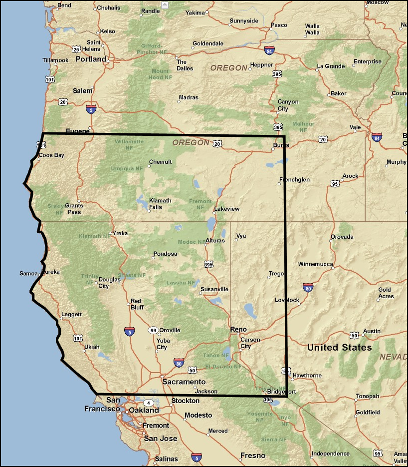
Jefferson Mining District Original Boundary Established
The Subsequent Boundary Enlargement Upon a request from miners outside the original boundary of Jefferson Mining District, desiring not to create their own mining district, petitioning their desire to be included within and be a part of Jefferson Mining District, and by their intention and current participation engaging the congressional mandate of Coordination, which purpose is to protect themselves and others from Government actions not consistent with the Mining Law, or rights thereby, Jefferson Mining District, within the power to so decide, the Assembly, after 3 months of research, deliberation, and consideration, duly, of motion and second, unanimously voted, on February 15, 2013, to expand Jefferson Mining District to accommodate their request. Without prejudice to any other jurisdiction, the newly established Jefferson Mining District boundary is declared, approximate, to wit,: Beginning at a point, the North West Corner, West of Astoria, about 46.229431,-124.01792; Thence
East along the course of the Columbia River, thence, along the 46th parallel north to the North East Corner, a three thousands feet peak, about 45.993354,-116.021547; Thence
South to the South East Corner, Revelle Peak, about 37.853712,-116.135831; Thence
West to the South West Corner, Point Reyes, about 37.996129,-123.021984; Thence
North along the low water mark of the coastline to the point of beginning.
|
The South West Oregon Mining Association (SWOMA) is an organization of miners and others based in South Western Oregon that are interested in defending our mining, property, water, access and other rights.
The South West Oregon Mining Association (SWOMA) was first founded by over 150 local miners who met at the Josephine County Courthouse at Grants Pass, Oregon on October 19th, 1936. As reported in the Grants Pass Daily Courier, the association was originally formed to give local miners a voice within the Works Progress Adminstration program during the Great Depression. Robert E. Kelly was elected as the first President, with R.J. Elder as Vice-President, Pat Dineen as Secretary and Harold Locke as Treasurer.
Later, with their mining rights on the Rogue River under heavy attack by the government of the State of Oregon, members of SWOMA re-organized the famous Galice Mining District in 1937. On August 12th, 1937, miners who answered SWOMA's public call for a miner's congress, met at the Galice Schoolhouse for the purpose of re-organizing the Galice Mining District as a local miner's government. This was at the height of the so-called "Rogue River Mud Mining" case which sought to enjoin sixteen Galice area miners, starting with a short lived order from local water master Tom Pearce to shut down local hydraulic mines in July of 1935.
SWOMA promotes a "don't give them one inch" approach and is actively working to educate miners, farmers, timber workers and others who make their living from the land about their rights. Off Road Vehicle, Fishing, Hunting, Hiking and other groups who utilize public lands and public highways are also encouraged to attend. Other activities at the meetings include ocassional demonstrations of the latest in mining equipment, as well as educational workshops on mining law, property law, right of way and other topics. Some of our past workshops have covered topics such as how to file a suit in small claims court, how to get your property back to its patent status, the co-ordination process and other items of interest.
SWOMA meetings are open to the general public. They have attracted people such as Josephine County Commisioner Sandi Cassanelli, Josephine County Sheriff Gil Gilbertson, Oregon Congressional Candidate Art Robinson, Oregon House District #3 Candidate Barbara Gonzalez, Josephine County Commisioner Candidate Jack Brown, Josephine County Commisioner Simon Hare and others of prominence. Political representatives, law enforcement and employees of BLM, USFS, DSL, DEQ, Water Resources and other management agencies are also encouraged to attend, as well as members of the local press. In the past, we have had employees from BLM and the Oregon Water Resources in attendence, as well as members of the press from Apple Rogue Times and the US Observer.
Learn more about our meetings here.
Jefferson Mining District is copyright 2011 by Jefferson Mining District. All Rights Reserved.